Landmannalaugar: Brennisteinsalda & Bláhnúkur Loop
Rainbow rhyolite peaks, steaming vents and obsidian lava, finished with a natural hot pool.

- Distance
- 11 km
- Loop
- Time
- 4–5 hours
- Ascent
- 600 m
- Max 945 m
- Difficulty
- Moderate
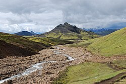
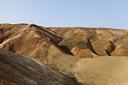
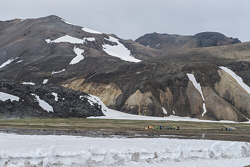
Of all the landmannalaugar hikes, the loop over Brennisteinsalda and Bláhnúkur is the one that shows off the area best. In about 11 km you climb through the Laugahraun obsidian lava field, past steaming vents to the sulphur-streaked slopes of Brennisteinsalda, and up to the summit of Bláhnúkur for a view over a sea of rhyolite peaks in shades of red, orange, green and cream. It is the classic introduction to the highlands of Iceland, and it ends back at the natural hot spring.
Landmannalaugar sits in the Fjallabak Nature Reserve at roughly 600 m altitude, and is both the start of the Laugavegur trail and a destination in its own right. The loop takes four to five hours with about 600 m of ascent. Trails are marked with coloured stakes, though junctions are numerous, so carry a map or download one. If you have more time, the area offers plenty of other walks, from the short Laugahraun circuit to longer ridge routes, all starting from the same hut.
Most visitors come on a day trip by bus or super jeep, which typically allows enough time for this loop and a soak. Staying overnight at the hut or campsite is even better: you can catch the low evening light on the mountains, add a second hike the next morning, and have the hot spring almost to yourself once the day tours have left. Either way, come prepared for highland weather, which can be cold and windy even on a bright July day.
Highlights
- The Laugahraun lava field, glittering with black obsidian
- Steaming fumaroles and sulphur colours on Brennisteinsalda
- Summit views from Bláhnúkur over the rhyolite mountains
- A soak in the natural warm pool by the hut at the end
The route
Through Laugahraun lava
From the hut and campsite the trail climbs onto the edge of Laugahraun, a jagged rhyolite and obsidian lava flow only a few centuries old. The path winds between glassy black boulders and up onto the lava plateau. This first section shares the start of the Laugavegur trail, so it is the busiest part of the loop.
Brennisteinsalda
The trail continues past hissing steam vents to Brennisteinsalda, the Sulphur Wave, whose slopes are streaked yellow, red, blue-grey and green. A short climb to its top gives a broad view south over the Laugavegur route. Stay on the path around the geothermal areas: the ground can be thin and scalding underneath.
Bláhnúkur summit and descent
Cross the valley and climb Bláhnúkur, the Blue Peak, at about 945 m. The ascent and descent are steep, on loose grey scree that is slippery when wet, and the summit is exposed to wind. From the top you see the whole Landmannalaugar basin, braided rivers and peaks in every colour. The descent drops back down near the lava edge and returns to the hut.
Getting to the trailhead
Landmannalaugar is reached only on F-roads, which require a 4x4. The usual route from Reykjavík is via Road 26 and then F208 from the north, which typically has no major river crossings until the final ford beside the hut; there is a car park before the ford and a footbridge for walkers. A parking fee is charged per vehicle, and in recent summers (roughly 20 June to 13 September) anyone arriving between 09:00 and 16:00 has had to book a parking slot in advance on parka.is. F225 and the southern section of F208 have more river crossings. If you do not want to drive, a bus to the Landmannalaugar trailhead is easy in summer: Reykjavík Excursions, Trex and Iceland by Bus typically run daily services from Reykjavík, taking around four hours each way and allowing a few hours on site.
Where to stay
FÍ runs the Landmannalaugar hut, which is popular and must be booked in advance, along with a large campsite on gravel with toilets and showers. The campsite is windy and cold at night even in summer, so bring a sturdy tent and a warm sleeping bag. There is no hotel; the nearest roofed alternatives are a few highland lodges and the guesthouses of the Hella and Hvolsvöllur area, a long drive away. Wild camping is not allowed in the nature reserve.
Best time to hike
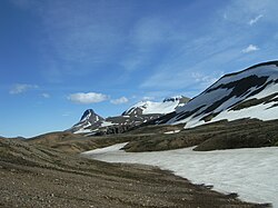
The F-roads to Landmannalaugar usually open in mid to late June and close again in September, depending on snow. Late June can still see snow on Bláhnúkur and on the higher paths. July and August are the most reliable months and also the busiest; the hot spring is crowded in the middle of the day when buses arrive. Early mornings and evenings are quieter and have the best light on the coloured slopes.
Safety
Weather changes quickly at this altitude, so bring waterproofs and warm layers even on sunny days, and check vedur.is before setting out. Stay on marked trails in geothermal areas, where crusts can hide boiling water. Bláhnúkur's scree is loose and steep; poles help. Do not attempt river fords in a 2WD car or a small 4x4 that is not built for them, and check road status on umferdin.is. Leave a travel plan at safetravel.is for longer hikes, and call 112 in an emergency.
Plan & book
Book your Landmannalaugar hike
 Transport
Highland Bus to Landmannalaugar
Daily summer buses from Reykjavík to the Laugavegur trailhead. No 4x4 needed.
Reykjavik Excursions · Trex
Booking coming soonHuts & staysMountain Huts (Ferðafélag Íslands)
Book bunks in the Laugavegur and highland huts. Summer dates sell out months ahead.
Ferðafélag Íslands (FÍ)
Booking coming soonGuided tourLandmannalaugar Day Tour from Reykjavík
A 4x4 or highland-bus day trip with time to hike the rhyolite mountains and bathe in the hot spring.
Licensed Icelandic operators10–12 hours
Booking coming soonGuided tourHighland Super Jeep Tours
No 4x4? Modified super jeeps cross the rivers and F-roads for you, with short hikes on the way.
Licensed Icelandic operators1 day
Booking coming soonOnline booking is coming soon. Until then, use this list to see what to plan for this hike.
Landmannalaugar FAQ
How do I get a bus to the Landmannalaugar trailhead?+
In summer, Reykjavík Excursions, Trex and Iceland by Bus typically run daily highland buses from Reykjavík to Landmannalaugar, some also stopping at Hella or Hvolsvöllur. The trip takes around four hours each way. Day-return timings usually leave several hours for a hike and a soak. Book ahead in July and August.
What are the best Landmannalaugar hikes for one day?+
The Brennisteinsalda and Bláhnúkur loop is the classic, taking four to five hours. Other good options include the shorter Laugahraun lava loop, the walk up Brennisteinsalda alone, and the longer Suðurnámur ridge. With extra time, many people walk the first stage of the Laugavegur towards Hrafntinnusker and return.
Can I drive to Landmannalaugar in a normal car?+
No. All roads to Landmannalaugar are F-roads, and rental agreements forbid taking 2WD cars on them. Even with a 4x4, the final ford beside the hut can be deep; many drivers park before it and walk across the footbridge.
Can you swim in the Landmannalaugar hot spring?+
Yes. A natural warm pool where hot and cold streams mix sits right beside the hut, with a wooden platform for changing. Temperature varies with where you sit. It is free to use, but please follow the posted rules and do not use soap in the water.
Hike it with a private guide
Guided trips with a licensed Icelandic guide, including transport and huts.
Private guide requests are coming soon
We are lining up licensed local guides. Check back soon to request a tailored quote for your trip.