Vík: Reynisfjall Ridge
Reynisfjall
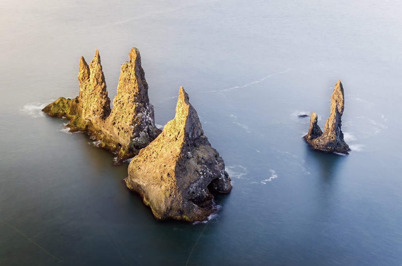
Puffin cliffs and a bird's-eye view of the Reynisdrangar sea stacks above Vík.
- Distance
- 7 km
- Loop
- Time
- 2.5–3 hours
- Ascent
- 350 m
- Max 220 m
- Difficulty
- Easy
Of all the Vik hiking trails, the walk up Reynisfjall is the best way to see the village and its famous sea stacks from above. Reynisfjall is the steep-sided mountain that rises just west of Vík í Mýrdal in south Iceland, and from its top you look straight down on the Reynisdrangar sea stacks, along the black-sand beaches and across to the arch of Dyrhólaey. In summer, puffins nest in the grassy cliffs along the edge.
The loop is about 7 km with around 350 m of ascent and takes two and a half to three hours. It follows a gravel track that climbs from the western edge of the village up onto the flat top of the mountain, continues along the plateau to viewpoints near the southern tip above Reynisdrangar, and returns along a lower path below the bird cliffs on the eastern face. The track is steep at first but easy underfoot.
It is a quieter alternative to the crowded beach at Reynisfjara on the other side of the mountain. Go in the evening for golden light and fewer people, and keep an eye on the wind, which can be fierce on top. In summer, bring binoculars for the puffins and other seabirds on the cliffs. Fulmars and other seabirds ride the updrafts along the edge too, and in late summer the plateau is carpeted with wildflowers and berries.
Highlights
- Bird's-eye view of the Reynisdrangar sea stacks
- Puffins nesting on the cliffs in summer
- Views along the black-sand beaches to Dyrhólaey
- A quiet alternative to busy Reynisfjara
The route
Vík to the plateau
From the western edge of Vík, a gravel track climbs steeply up the eastern slopes of Reynisfjall. The gradient eases as you reach the flat, grassy plateau on top. Views over the village, the church and the beach open up as you climb. The track is used by vehicles occasionally, so stay alert.
Along the plateau to the cliffs
On top, the track continues south across the plateau to the cliffs above Reynisdrangar. The cliff edges are sheer and in places undercut, so keep well back. Puffins nest in the grassy slopes below the edge in summer; watch from a distance and do not approach burrows. From the southern tip, return along the lower path beneath the bird cliffs on the eastern face, back to the village.
Getting to the trailhead
Vík is on the Ring Road about two and a half hours' drive from Reykjavík. The track up Reynisfjall starts at the western edge of the village; parking is available nearby. Public buses along the south coast stop in Vík, and many south coast tours pass through.
Where to stay
Vík has hotels, guesthouses and a campsite on the edge of the village. Nearby farms and guesthouses along the coast offer more options. Wild camping on Reynisfjall is not permitted.
Best time to hike
Reynisfjall can be walked year-round. Summer is best for puffins, which usually nest from around May to August, and for long daylight. Winter brings short days, strong winds and icy tracks. Evenings are quietest and have the best light over the sea stacks.
Safety
The cliff edges are sheer and undercut; keep well back, especially in strong wind. Wind on the plateau can be severe, so check vedur.is. In winter the track can be icy. If you visit Reynisfjara afterwards, beware of sneaker waves, which have killed visitors; never turn your back on the sea. Call 112 in an emergency.
Plan & book
Book your Vík hike
 Glacier hike
Sólheimajökull Glacier Hike
The most accessible glacier hike in Iceland, 2.5 hours from Reykjavík near Vík.
Certified glacier guides3 hours (or day trip)
Booking coming soonGuided tourSouth Coast Tours
Seljalandsfoss, Skógafoss, Vík and the glacier lagoon. Multi-day versions reach Skaftafell.
Licensed Icelandic operators1–3 days
Booking coming soonOnline booking is coming soon. Until then, use this list to see what to plan for this hike.
Vík FAQ
What are the best Vík hiking trails?+
Reynisfjall is the best short hike from Vík, with views of Reynisdrangar. Nearby, Hjörleifshöfði and the trails at Þakgil are good options, and Dyrhólaey has short walks along the cliffs.
How long is the Reynisfjall hike?+
The loop is about 7 km with around 350 m of ascent and takes two and a half to three hours.
Can you see puffins on Reynisfjall?+
Yes, puffins usually nest on the cliffs from around May to August. Watch from a distance and do not approach the edge or burrows.
Can I hike Reynisfjall in winter?+
Yes, but the track can be icy and the wind fierce. Wear microspikes and check the forecast before setting out.
Hike it with a private guide
Guided trips with a licensed Icelandic guide, including transport and huts.
Private guide requests are coming soon
We are lining up licensed local guides. Check back soon to request a tailored quote for your trip.