Krýsuvík Geothermal Area
Krýsuvík – Seltún
A 6.5 km loop from the bubbling mud pots of Seltún into the hills of the Krýsuvík geothermal area on Reykjanes.
- Distance
- 6.5 km
- Loop
- Time
- 1.5–2.5 hours
- Ascent
- 190 m
- Max 330 m
- Difficulty
- Moderate
The Krýsuvík hike starts at Seltún, one of the most colourful geothermal areas in Iceland, and loops 6.5 km through the surrounding hills on the Reykjanes Peninsula. Allow 1.5–2.5 hours for about 190 m of ascent, with a high point of 330 m. It is close to Reykjavík, open all year in principle, and gives you far more than the short boardwalk most visitors see.
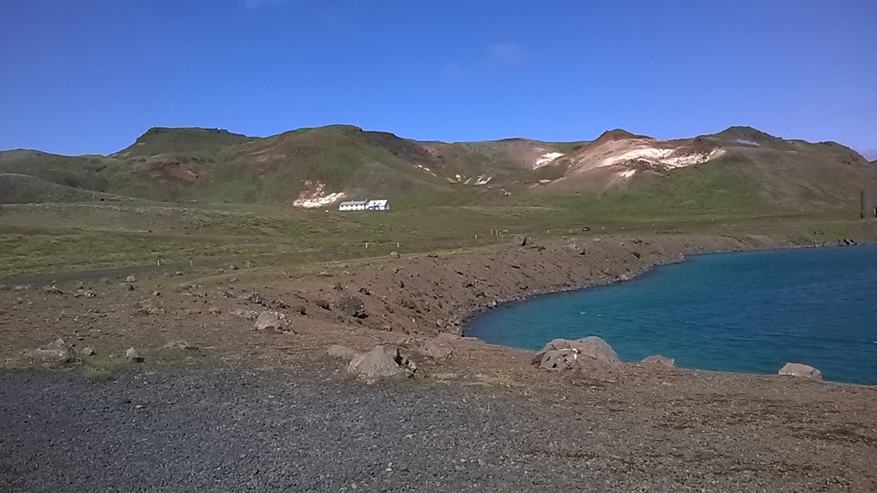
Seltún itself is a field of steaming fumaroles, boiling mud pots and slopes stained yellow, red and ochre by sulphur and clay. From there the trail climbs into the hills above the valley, where you look down over Kleifarvatn lake, crater lakes and old lava fields stretching toward the south coast. The climbs are modest but steady, and the ground can be loose or muddy.
Highlights
- Boardwalk through the fumaroles and mud pots of Seltún
- Sulphur-coloured slopes in yellow, red and green
- Views over Kleifarvatn and the lava plains of Reykjanes
- The crater lake Grænavatn on the return
- An easy half-day trip from Reykjavík
The route
Seltún geothermal field
Start at the car park at Seltún and walk the boardwalk loop through the hot area first. Steam vents hiss beside the path, and grey mud bubbles in pools below. The colours are strongest after rain. Information boards explain the geology. Everything off the boardwalk is potentially unstable, so do not step onto the crust, however solid it looks.
Climb into the hills
Marked paths lead up from the geothermal field onto the slopes above. The climb is steady rather than steep, on gravel, moss and sometimes muddy ground, and reaches the route's high point of 330 m. From up here you see the steaming valley below, Kleifarvatn to the north and the dark lava fields running down toward the ocean.
Loop back to Seltún
The return section descends from the hills and heads back north along Route 42, passing the crater lake Grænavatn before arriving back at the Seltún car park. The descent can be slippery after rain, so take it slowly, and watch for traffic on the road. If you still have energy, drive along the shore of Kleifarvatn afterwards.
Getting to the trailhead
Krýsuvík is roughly 35–45 minutes' drive from Reykjavík via Hafnarfjörður and Route 42, which passes Kleifarvatn before reaching the Seltún car park. Part of the road is gravel and can be rough or icy in winter. There is no regular public transport. Because of volcanic activity around Grindavík, check SafeTravel.is and local notices for current road and area access.
Where to stay
Most hikers do this as a day trip from Reykjavík or Hafnarfjörður, where there is plenty of accommodation. Grindavík has been affected by eruptions and evacuations since 2023, so check its status before planning to stay on the southern side of the peninsula.
Best time to hike
The area is accessible all year, though winter can bring snow, ice and short days. Late spring to early autumn is easiest, with drier paths and long daylight. Geothermal colours stand out well under overcast skies, and steam is most dramatic on cold, still days.
Safety
Geothermal ground is the main hazard: stay on boardwalks and marked paths, as the crust near vents can be thin and the water and mud are boiling. Hills can be windy and slippery in rain or ice. Reykjanes is volcanically active, and areas near Grindavík have been closed at times; check SafeTravel.is for current access. Call 112 in an emergency.
Plan & book
Book your Krýsuvík Geothermal Area hike
 Guided tour
Volcano Hikes on Reykjanes
Guided hikes to the Fagradalsfjall eruption sites and Reykjanes lava fields, often with pickup in Reykjavík.
Licensed Icelandic operators4–7 hours
Booking coming soonGear rentalHiking & Camping Gear Rental in Reykjavík
Rent tents, sleeping bags, stoves, poles and microspikes instead of flying them over.
Reykjavík outfitters
Booking coming soonOnline booking is coming soon. Until then, use this list to see what to plan for this hike.
Krýsuvík Geothermal Area FAQ
How long is the Krýsuvík hike?+
This loop from Seltún is 6.5 km and takes 1.5–2.5 hours, with about 190 m of ascent. If you only walk the Seltún boardwalk, plan on 20–30 minutes.
Is the Krýsuvík geothermal area safe to visit?+
Yes, as long as you stay on the boardwalks and marked paths. The ground near hot springs and mud pots can be thin and scalding. Also check SafeTravel.is for any volcanic-activity closures on Reykjanes.
Is Seltún open in winter?+
The area is generally accessible all year, but Route 42 can be icy or snowbound, and the boardwalk and hill paths may be slippery. Check road.is and the forecast before you go.
Is the Krýsuvík hike hard?+
It is rated moderate. The climbs total about 190 m and are steady rather than steep, but the full loop takes a couple of hours and the ground can be muddy or loose.
Hike it with a private guide
Guided trips with a licensed Icelandic guide, including transport and huts.
Private guide requests are coming soon
We are lining up licensed local guides. Check back soon to request a tailored quote for your trip.